What are conceptual models?
Conceptual models are concise and visually-stimulating illustrations that use symbols or drawings to depict the important features, processes and management challenges in a particular environment, such as coastal waterways. This is accomplished using the most current knowledge or understanding of that particular environment and is presented in a way that is easy to understand. Conceptual models should evolve in tandem with knowledge as it is expands with research developments.
Why use conceptual models?
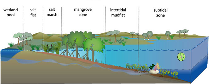
![]() Groundwater
Groundwater ![]() Seagrass meadows
Seagrass meadows ![]() Salt marsh
Salt marsh ![]() Macroalgae
Macroalgae ![]() Benthic microalgae
Benthic microalgae ![]() Phytoplankton
Phytoplankton ![]() Mangroves
Mangroves ![]() Terrestrial vegetation
Terrestrial vegetation
Figure 1. Conceptual diagrams of estuarine vegetation.
Conceptual diagrams are useful because they:
- Facilitate communication. Conceptual models are a tool through which detailed technical concepts can be summarised in a non-technical way, and presented to end users such as environmental managers and other coastal zone stakeholders.
- Integrate knowledge across disciplines. Conceptual models provide a physical background upon which the understanding derived from various scientific disciplines (e.g. ecology, chemistry and geology) can be integrated with the perspectives of other stakeholder groups for addressing management issues.
- Increase understanding. Conceptual models help users to understand the often complex processes in a system (e.g. how things work, what drives these things and major impacts) and demonstrate the links between them.
- Identify knowledge gaps. Conceptual models can help users to identify any gaps in scientific understanding, monitoring or natural resource management plans.
- Help with decision making and planning. Conceptual models can assist environmental/natural resource managers and stakeholders in developing coastal waterway management plans and prioritise research and monitoring efforts.
- Facilitate participation. Conceptual models can facilitate participation of stakeholders, and assist with interaction between different stakeholder and government groups.
Using models to determine indicators
To develop an appropriate set of indicators to monitor an estuary there is a logical process that needs to be followed (see Fig. 1). The first part of the process is to determine what type of estuarine wetland you are monitoring (i.e. its typology). Currently there is no comprehensive typology of Australian estuaries, however, the geomorphic classification presented here is a initial start and is currently the national default typology. Developing a typology allows different types to be recognised, this is an important step to group similar estuaries together, ensuring that ‘apples’ can be compared with ‘apples’. The next step in the process is to produce science models which synthesise the current understanding of each type’s key processes, components and functions, thus providing a basis of sound understanding for the development of individual stressor models. These stressor models then allow pressure and condition indicators to be determined that are specific to a particular estuarine type.
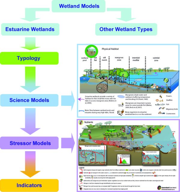
Figure 2. Flow chart showing the process needed to determine appropriate indicators for monitoring an estuary.